The Dover Road: Britain's Highway to the World
Before the Romans: The Ancient Trackway
The Dover Road didn't begin with the Romans. Long before Caesar's galleys appeared off the Kent coast, people were walking this route. The geography made it inevitable. Southeast England tilts towards the continent. The Thames estuary funnels travellers towards a natural crossing point at London. From there, the North Downs—a long ridge of chalk hills—provide a natural highway running east towards the sea.
Bronze Age traders used this route. We know because of what they left behind: hoards of bronze axes and weapons, deposited along the path. The famous Dover Bronze Age Boat—now in Dover Museum, one of the most remarkable prehistoric artefacts in Britain—shows that cross-Channel trade was flourishing by 1500 BC.
Caesar's Invasion: 55-54 BC
Julius Caesar's two expeditions to Britain—in 55 and 54 BC—were the first recorded contacts between Rome and the island that would become England. And both expeditions landed near Dover.
The first expedition, in late summer 55 BC, was a reconnaissance in force. Caesar had conquered Gaul and wanted to punish the British tribes who had been helping his Gallic enemies. The ships arrived off the Dover cliffs to find the heights lined with British warriors. Landing there was impossible. Caesar sailed northeast along the coast and eventually beached his ships near Deal.
The famous story of the standard-bearer of the Tenth Legion—who leapt into the waves crying 'Jump down, soldiers, unless you want to betray your eagle to the enemy!'—dates from this moment.
— Historical Account
The second expedition, in 54 BC, was more serious: five legions, 2,000 cavalry, 800 ships. Caesar marched inland, crossed the Thames somewhere near modern London, and defeated Cassivellaunus, the British war-leader. But the route was established: from the Kent coast, northwest towards the Thames crossing.
Watling Street: The Roman Road
In AD 43, the Emperor Claudius launched the invasion that would make Britain a Roman province. Four legions landed on the Kent coast and fought their way to the Thames. Within months, Roman Britain was born.
The Romans were legendary road-builders, and Watling Street was one of their first and most important British projects. The road ran from Richborough (the main Roman port on the Kent coast) through Canterbury (Durovernum) and Rochester (Durobrivae) to London (Londinium).
- Surveying: Engineers marked the straightest possible route between points
- Excavation: A trench was dug and filled with successive layers
- Foundation: Large stones at the bottom, smaller stones above
- Surface: Gravel or paving stones, cambered to shed water
- Drainage: Ditches on either side to carry away runoff
The result was a road that could be used in all weathers, that supported heavy traffic, and that lasted—in some places, it's still in use two thousand years later.
Roman Dover: The Pharos and the Fort
At the Dover end of Watling Street, the Romans built one of Britain's most remarkable structures: a lighthouse. The Roman Pharos still stands within the walls of Dover Castle. It's the oldest standing Roman building in Britain—and one of only three Roman lighthouses surviving anywhere in the world.
The lighthouse was originally about 80 feet tall. It was octagonal, built of flint and tile in courses that are still clearly visible. At the top, a fire would have burned at night, guiding ships through the treacherous straits.
The Coming of Christianity: St Augustine's Journey
In AD 597, a group of about forty monks landed on the Isle of Thanet, at the eastern tip of Kent. Their leader was Augustine, sent by Pope Gregory the Great to convert the pagan English to Christianity.
The King of Kent, Ethelbert, gave Augustine permission to preach and provided him with a base at Canterbury. Canterbury became the headquarters of English Christianity. Augustine was consecrated as the first Archbishop of Canterbury—a title that still exists today.
The Murder in the Cathedral: Becket and the Pilgrims
No event did more to shape the Dover Road than the murder of Thomas Becket in 1170. Becket was Archbishop of Canterbury, former friend and chancellor of King Henry II, and by 1170, the king's bitter enemy.
On 29 December 1170, four knights who believed they were doing the king's bidding burst into Canterbury Cathedral and murdered Becket before the altar. The shock was immense. Miracles were reported at Becket's tomb almost immediately. Within three years, he was canonised as a saint.
For the next 350 years—until Henry VIII destroyed Becket's shrine in 1538—pilgrims streamed to Canterbury from all over England and Europe. Many of them came via Dover, combining pilgrimage with travel to or from the continent.
— Pilgrimage History
Geoffrey Chaucer's Canterbury Tales, written in the 1390s, immortalised these pilgrimages. His pilgrims set out from the Tabard Inn in Southwark and travel to Canterbury, telling stories along the way.
Dover Castle: England's Key
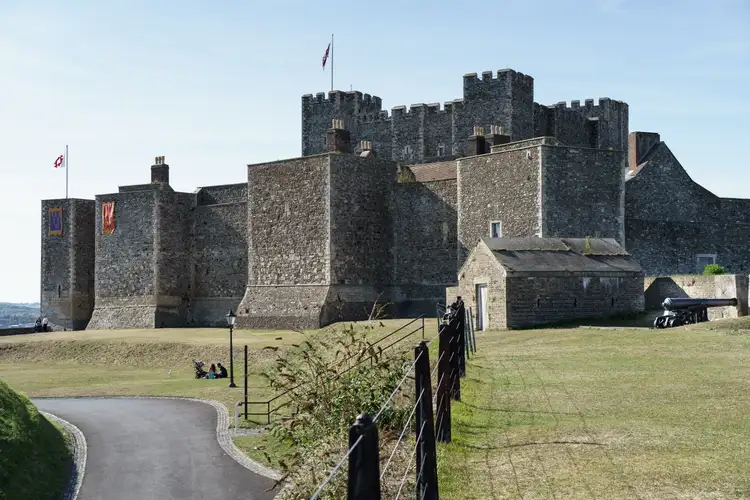
If the Dover Road was Britain's highway to Europe, Dover Castle was the lock on the door. There has been a fortress on the Dover heights since at least the Iron Age. But the castle we see today is fundamentally Norman—begun by William the Conqueror immediately after Hastings, and expanded by Henry II in the 1180s.
- The Great Tower: Henry II built this massive keep between 1180 and 1189. Walls up to 21 feet thick
- The Medieval Tunnels: Dug during the 1216-17 siege, designed to undermine enemy attacks
- The Secret Wartime Tunnels: WWII headquarters where Operation Dynamo (Dunkirk evacuation) was coordinated
- The Roman Pharos: Still standing within the castle walls
- Saxon Church: St Mary in Castro, adjacent to the lighthouse
Dover Castle has been called 'the Key to England'—and with reason. Whoever held Dover controlled the shortest crossing to France, commanded the Straits, and held the door to London.
The Age of the Stagecoach
The 18th and early 19th centuries were the golden age of road travel. Stagecoaches—regular scheduled services carrying passengers and mail—transformed long-distance travel. What had taken four days in the medieval period could now be done in twelve hours.
Charles Dickens—who lived in Kent and knew the Dover Road intimately—described the hazards in A Tale of Two Cities. The coaching era ended suddenly with the coming of the railways. The South Eastern Railway reached Dover in 1844.
Visiting the Dover Road: A Practical Guide
By Car: A Day Trip or Weekend
London to Dover: About 75 miles via M2/A2. Without stops, 90 minutes to 2 hours.
- Rochester (40 miles from London) — Cathedral and Castle, allow 2-3 hours
- Canterbury (60 miles) — Cathedral, St Augustine's Abbey, medieval streets. Allow half a day minimum
- Dover (75 miles) — Castle (allow half a day), Roman Pharos, Bronze Age Boat Museum, White Cliffs
By Train
Direct trains from London (St Pancras, Victoria, or Charing Cross) to Rochester (40 minutes), Canterbury (1 hour), Dover (1 hour 15 minutes).
A Final Thought
The Dover Road is more than a road. It's a thread connecting two thousand years of British history.
Stand on the White Cliffs and look towards France. Julius Caesar saw these cliffs from his galley in 55 BC. St Augustine saw them as the gateway to a mission that would shape English Christianity. Medieval pilgrims saw them as the last landmark on the way to Becket's shrine. Soldiers saw them in 1940 as the front line of a war for survival. The cliffs haven't changed. The road still runs from Dover to London, as it has since before recorded history.
— Historical Reflection